Arkansas River Corridor Development Plan
The effort to plan for appropriate development of the 42-mile Arkansas River corridor in Tulsa County is underway. The plan was structured in three initial phases and has now moved from planning to the design and permitting phase. In October 2010, Tulsa County signed a cost-sharing agreement with the US Army Corps of Engineers to proceed with the project. Tulsa County is the lead entity on this development project.
The Phase I and Phase II studies of the Arkansas River Corridor Master Plan, initiated by INCOG, were developed with extensive citizen and stakeholder input and have been adopted by the Tulsa Metropolitan Area Planning Commission (TMAPC), the Tulsa City Council, and the Tulsa County Board of County Commissioners as an element of the area's Comprehensive Plan.
The Phase I River Vision Plan captures the public’s desire for water in the river through additional low-water dams, preservation of the natural beauty of the corridor with trails, parks and open space, and river-oriented development at strategic locations. The Phase II study provided a detailed evaluation of the proposed plan elements including prospective low-water dams.
The Phase III study includes an ecosystem restoration study in conjunction with planned low-water dams, an environmental baseline, and recommendations for the design and operation of the system of low-water dams.
Phase I: Vision Plan
INCOG and Carter-Burgess completed the Phase I Arkansas River Vision Plan in July 2004. This plan was reviewed and approved by the Advisory & Steering Committees on August 3, 2004 and subsequently approved by the INCOG Board of Directors, TMAPC, Tulsa City Council, and the Tulsa County Board of County Commissioners as part of the comprehensive plan.
Arkansas River Development Phase I Documents:
Arkansas River Vision Plan
Vision Plan Graphic - *Arkansas River Upper Reach
Vision Plan Graphic - *Arkansas River Middle Reach
Vision Plan Graphic - *Arkansas River Lower Reach
*Revised September 2005 based on the final Phase II Master Plan
Back to Top
Phase II: Master Plan
The Master Plan Volume 1 may be viewed for your convenience in the following three PDF files. Once you have opened the PDF, we recommend using the Bookmarks tab on the left side of the page for navigation. Sections 1-8.0 and 8.1-8.11 are large files and may take some time to download.
Sections 1 - 8.0
Introduction
Description of Study Area
Study Methodology
Study Area Conditions
Habitat Assessment/Ecosystem Restoration
Technical Evaluation of Low Water Dams
Opportunities and Constraints
Sections 8.1 - 8.11
Sand Springs Low Water Dam
Creek Turnpike Low Water Dam
Sand Springs Riverfront Conceptual Plan
Zink Lake Riverfront
Crow Creek Corridor
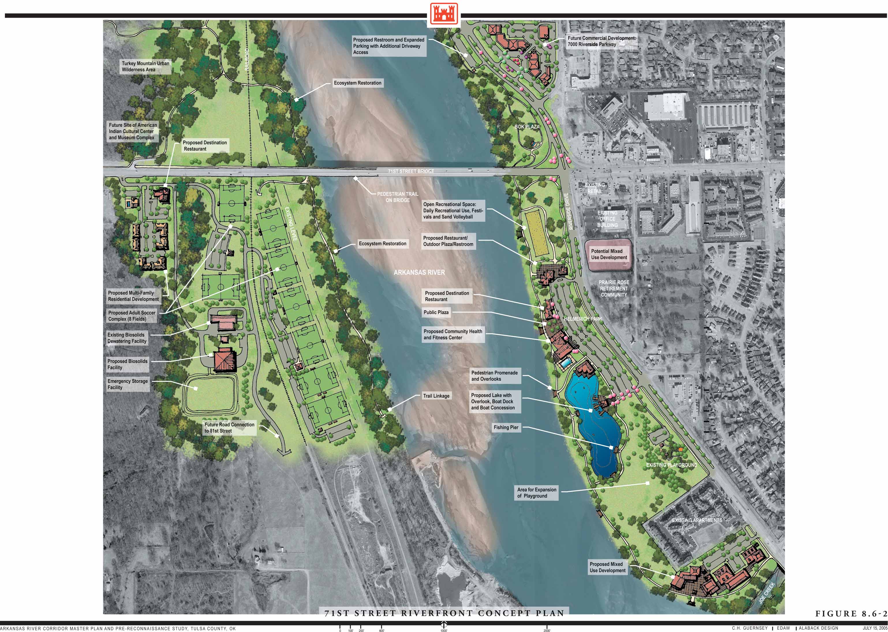
71st Street Riverfront
Jenks/South Tulsa Riverfront
Bixby Riverfront
Broken Arrow Riverfront
Ecosystem Restoration Plan
Floodplain Management Conceptual Plan
Sections 9.0 - 13.0
Public Involvement
Funding Mechanisms and Budget Projections
Conclusions and Recommendations
Glossary
References
Volume 2 Appendices:
Appendix A (PDF, 3.9 MB)
Appendix B (PDF, 7.2 MB)
Appendix C (PDF, 1.0 MB)
Appendix D (PDF, 0.5 MB)
Appendix E (PDF, 8.0 MB)
Appendix F (PDF, 7.3 MB)
Appendix F-Map (PDF, 3.5 MB)
Appendix G (PDF, 3.2 MB)
Appendix H (PDF, 0.6 MB)
Appendix I (PDF, 1.5 MB)
Appendix J (PDF, 0.4 MB)
Appendix K (PDF, 1.8 MB)
Appendix L (PDF, 4.5 MB)
This PDF summarizes the presentation given during the July 2005 public meetings.
Arkansas River Corridor Powerpoint Phase II (5.88 MB PDF)
Back to Top
Phase III: Preliminary Engineering & Environmental Data Collection & Evaluation
The construction of Keystone Dam was complete in 1964. The dam has successfully reduced the negative impacts of flooding along the Arkansas River in Tulsa County. However, changes have occurred to the natural flow regime of the river. These changes, in combination with land use changes in the watershed, have altered the river corridor ecosystem.
Phase III of the Arkansas River Development Plan is designed to look at the environmental impact on the river and evaluate options in protecting the natural beauty of the area.
Ecosystem Restoration Plan in Conjunction with Proposed Low Water Dams
Problems and Opportunities
Habitat Inventory and Improvement
Proposed Plans – Sand Springs
Restoration Recommendations – Sand Springs
Proposed Plans – South Tulsa/Jenks
Restoration Recommendations - South Tulsa/Jenks
Summary
Fauna & Flora Inventory
Fish Community Structure and Composition Assessment
Aquatic Macro Invertebrate Structure
Water Quality Assessment
Cultural Resource Evaluation
Back to Top
Conceptual Plan Graphics
Back to Top
|

